Until 1967, Syria controlled the Golan Heights, with the border of the two countries being the Jordan River in the south, up along the Kineret, and northwards along the Jordan River, and then the Banias Stream. Israeli civilians living along the Kineret, during this period, were subject to sniper fire from the Heights. The majority of the population living in the region was (and to some extent, still is) the Druze people who follow a religion based on oral tradition and secrecy. In 1967, Israel went to war with basically all of it's neighbors (Commandments be damned) in a series of battles known as the Six Day War. Basically all of Israel's neighbors except Lebanon were gearing up for war (Egypt, Jordan, and Syria), so Israel preemptively stuck Egypt's air force, causing a full-out war versus the three countries. They pushed Egyptian forces not only back to Sinai, but beyond all the way across the Suez Canal, capturing the Sinai peninsula. They pushed the Jordanian forces across the Jordan River, capturing the Old City of Jerusalem and subsequently annexing East Jerusalem and conquering Judea and Samaria (modern day West Bank). And in the north, they pushed the Syrian forces out of the Golan Heights, capturing and securing the northern border. Over 100,000 Syrians fled the Golan Heights following the war. In the aftermath, Israel's land area tripled in size.
The first day of hiking was, comparatively, pretty unremarkable, but even on the most bland of days hiking the trail, we were blown away. Since there were so many people hiking the trail at this time of year (spring break, woo), it felt at times more like a pilgrimage than a trek. Leaving Majdal Shams on the trail, we stared in awe at the snowfields atop Mount Hermon. We meandered through an artificial forest, finding our way to the top of an adjacent hill where there was a pretty legit campsite sporting some tepees and Bedouin tents. Strange.
 |
| Tepees with Hermon and Majdal Shams in the background |
We continued along the trail (a dirt road for farmers at this point) towards, and then through the Druze village of Mas'ade, passing some quaint farms with rows of flowering orchids. It was really quite picturesque.
 |
| Farms on the outskirts of Mas'ade |
After Mas'ade, we decided to call it a night, as sunset was quickly approaching. We tried to find our way to a campsite marked on the map, but got a bit lost and ended up having to stealth camp in the reservation. That night, the first night, we made a roaring fire that lasted a couple hours. Our two-person tent that we brought, as the namesake would suggest, only had room for two people, meaning that one of us had to take turns outside. Ari volunteered this night.
 |
| Fi-ya! |
Day 2: Odam Nature Reserve to Ein Ziwan (27km)
The second day was intense, in-your-face style hiking, more or less to see how far we could push ourselves in a day. Ari made it through fine. I was exhausted. Itai was unresponsive. Despite the strenuousness of the hike, the first full day of hiking was breathtaking and brought us to some of the furthest corners of Israel, giving us a unique experience I doubt anyone else on the program has had. We woke up at 6:30am and broke camp by 8. The trail wandered though the Odam Reserve a bit before breaking free of what I would assume to be an artificial forest into sprawling countryside. The views from behind Har Odam were incredible. The countryside was separated into different circular terraces meant for grazing animals some thousand or so years ago and were currently in disuse.
 |
| Countryside and Hermon |
The trial wrapped around the side of Odam and worked its way toward the regional "highway". The trail according to our book and markers went south of the Druze village of Buq'ata, but our map showed the trail going through the center of town. So we took our chances and hoofed it a kilometer up the road to Buq'ata, where we were greeted by friendly faces and happy children. Ari and I split a laffa filled with Druzi labne and zatar (Google those things if you don't understand Middle Eastern cuisine). As we walked through Buq'ata, I noticed that everyone was sitting around on their stoop on this beautiful day drinking yerba mate. It felt like I was back in Paraguay. We restocked on supplies at a local market and there again I noticed the abundance of yerba mate (and the lack of suitable food for camping). Strange.
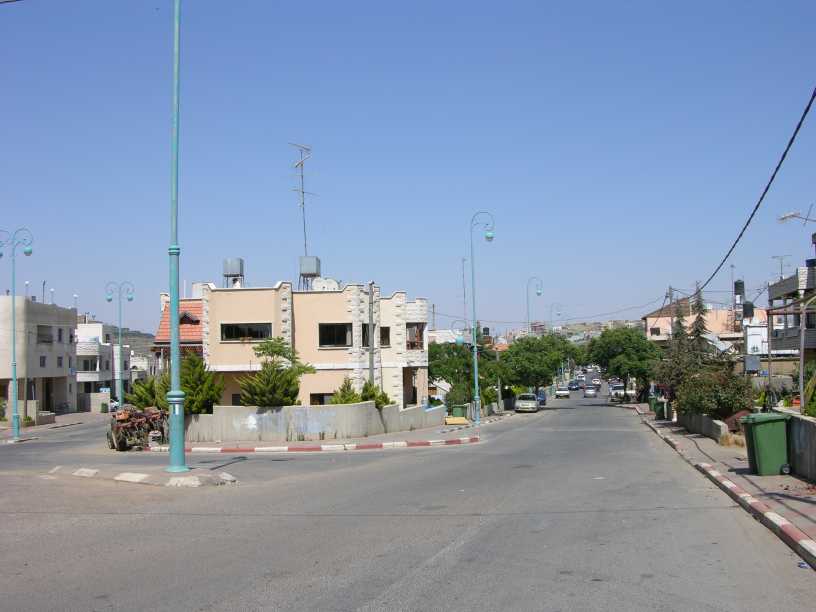 |
| Buq'ata (via Wikipedia) |
So we left Buq'ata, navigating the farm roads by map, until we hit a gate marked on the map. So we found it...the Old Golan Trail. What used to be a marked trail was now overgrown, although still a clearly defined path through the Hermonit Nature Reserve. As we walked on this trail, now navigating by compass and map, we stopped for a moment to appreciate the quiet, solidarity, and for me to take an incredibly meditative shit.
 |
| "I think this is the trail!" |
We met up with the regular trail in early afternoon on the eastern banks of Har (Hebrew for mountain) Hermonit (little Hermon). I'll stop to explain the views we were seeing here. To our north was Mount Hermon clearly visible, both the Israeli peak and the Syrian peak (a thousand meters higher). To the east of that was the UN Buffer Zone defined by the valley between the Golan Heights and Syrian mountains visible in the distance. In the valley itself were a few Syrian villages clearly visible, especially with Itai's binoculars. Due east of us was Syria. There were some hills south of us still in Israel with active military outposts, not to mention the outpost on top of Har Hermonit itself. This entire panorama was seen while standing on top of an abandoned Syrian tank directly adjacent to a minefield. Welcome, my friends, to the Golan Heights. I think at the closest point we were about 500 meters away from Syria.
 |
| Tanks for the land, Syria (too soon?) |
The trail then turned back toward Israel, where we passed a reservoir (Ari took a dip), bought some delicious apples along the trail, and began to climb Mount Bental. Now if you're a tourist in Israel, there's a good chance you'll come to this mountain. Hell, Aardvark brought us here on our first field trip. Anyways, the trail climbs up the backside, and when I say climb, I mean climb. I'm not sure why it wiped me out as much as it did, but towards the end of a long day of hiking, the last thing you want to do is climb 200 meters in the span of a kilometer.
The peak of Mount Bental afforded us magnificent views of the Golan. Hermon was still pronounced and visible to the north. South of us was Mount Avital, an interesting crescent-shaped mountain, and further south and west were volcanic cones that dotted the Golan Heights. To the east was Quneitra, the abandoned and destroyed capital of the Syrian governate in the Golan Heights. The city has a rich history dating back hundreds of years. During the 1967 War, the Israeli forces were pushing the Syrians out of the Golan Heights and started to put pressure on the city of Quneitra, population 20,000 (huge for the region). Before the Israeli forces got to the city, Syrian command accidentally broadcast an order saying that Israel had captured Quneitria and to abandon post and flee the city. So three hours later when Israel launched its offensive against the town, the fierce counter-attack they were expecting never happened. Instead they were greeted by a completely abandoned and looted city, with the Syrian forces even leaving behind weapons and fully-operational tanks. Quneitria remains largely abandoned to this day. Unfortunately for my adventuresome side, the city is in the UN Buffer Zone and thus is off-limits to everyone.
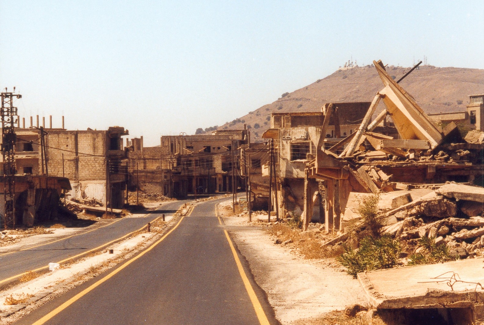 |
| Quneitra (via Wikipedia) |
Back to the hike...we finished the hike a couple hours after summitting Bental and camped next to a tank in the woods across from Kibbutz Ein Ziwan. End day.
 |
| Ari and Itai and a vineyard |
Day 3: Kibbutz Ein Ziwan to Keshet Settlement (22km)
I woke up in the morning at the standard time of 6:30 and rolled out of bed into a cup of coffee. It wasn't until 8:30 that we left camp, and wasn't until 9:30 that we finished restocking on supplies at Kibbutz Ein Ziwan (our fuel ran out the night before...terror).
 |
| Wind turbines and mines...did I mentions the mines? There's a lot of mines |
Our walk began as per usual: walking through some footpath through the countryside with sweeping views of Hermon in the background. The trail turned towards a series of wind turbines atop a hill. These things were huge, towering over the horizon. Unfortunately, this wind farm is the only one of it's kind in Israel, and half the turbines aren't functional. Still, to walk beneath these behemoths was quite the experience. We found an abandoned bunker at the other end of the hill, where we went underground and explored it with flashlights. We descended the hill and ended up in a nature reserve that incorporates eight volcanic ash cones (volcanic hills). The path through the park was spectacular: narrow, meandering, and hilly. After we left the park, the day's walk turned to a boring walk for a few miles down farm roads, and we somehow managed to still get lost and finding our way toward Syria.
 |
| "I'm bonkers for bunkers!" |
Late in the afternoon, we came upon a totally demolished Syrian village. We spent a good chunk of time exploring the concrete shells of houses that once were, and now were no more than slabs riddled with artillery shells and bullet holes. In the distance, we saw a minaret towering over the artificial forest, so we bushwhacked towards it. Once we got there, we were greeted by an incredible sight: a totally abandoned mosque and adjacent minaret. The mosque itself was covered in graffiti, ranging from "Fuck Israel" to "Na Nach Nachma Nachman Meuman", kind of terrible defacement of a holy sanctuary if you ask me. The real treat came when we realized that we can walk up the minaret. So we climbed the spiral staircase up about six stories to the top of the tower once used to call people to worship. It was freaky being up that high in a concrete structure at least fifty-years-old that was decaying and had bullet holes everywhere. But it was worth it. The view from the top was incredible, with Hermon still visible in the distance.
 |
| Abandoned and destroyed mosque and minaret, vandalized in every way possible (tsk tsk) |
After exploring the village, we set out toward Keshet Settlement, a couple kilometers off the road. We tried to get there a legitimate way, but the path we set out on turned into an animal path through the waist-high wheat-grass, so we bushwhacked the last couple of kilometers and finally ended up at this beautiful yishuv with a central lawn to camp on and dogs to keep us company.
 |
| Dog |
I slept outside that night, but I think I slept pretty well and comfortably.
Day 4: Keshet Settlement to Synagogue Oom-El-Knateer (30 km)
Our day started early at Keshet, where we restocked on supplies and got directions back to the trail. As soon as we reunited with the Shvil, we found the trail to be quite underwater. I decided to trust my Gortex boots and not waste the time to don my water shoes. Unfortunately, waterproofed boots are not that waterproofed and I got a bit wet. Oh well. We continued the hike past some pastures, where we mingled with some friendly horses.
 |
| Southern Golan countryside...walla (did I do it right?) |
The fourth day of hiking was defined by poorly-marked narrow footpaths through knee to waist-high wheat-grass. The whole morning was spent in this manner, basically going as fast and far as we could. We set down for lunch on a peninsula of lake and relaxed for a half-hour. We picked up the pace (race) after lunch, getting significantly lost a couple times, and having to navigate by compass and map. The trail brought us to a vantage point of the Gamla Reserve, which is a giant valley from the Golan plateau down to the Sea of Galilee...beautiful.
 |
| Yep |
So we continued yet again on this, the most intense day of hiking, ending up walking though a valley following Nahal Samekh. Along the way, we met this group of fun-loving Israelis who told us about this great campsite at an ancient synagogue. So we booked it though this valley all the way to this synagogue, concluding the longest hike I've done in a single day (18.5 miles).
 |
| Ancient Hebrew ruins near Keshet |
The place we camped out at was incredible. Basically we camped next to an ancient Mikvah (a body of water meant for purifying oneself). A bit up this footpath were the ruins of an ancient village centered around a synagogue dating back to the 4th century. There was restoration work going on to turn the synagogue into an active one. From the footpath, you could see the Sea of Galilee through the beautiful valley, with the city of Tiberias in the background.
 |
| Packing up camp at the Mikvah |
We camped out with this group of hikers who, for lack of any other descriptions, were characters. As night fell and their fire got started, they invited us over for cheers. We all went around with a bottle of wine toasting to the day's trials and tribulations, girls they encountered on the trail, jokes about how much your mother doesn't love you, etc. I think the style they camped out in really exemplified Israeli culture, with a strong sense of camaraderie. As their fire picked up, the began cooking a veritable feast: mashed potatoes with onion, roasted eggplant with tahini, roasted onion and tomato, israeli salad, and rice. They basically fed us a second dinner...not complaining. As the night winded down, they offered Ari a spot to sleep in their spare tent so he didn't have to brave the elements.
Day 5: Oom-El Kinateer Synagogue to Nahal Meitzar Reserve (22 km)
Our hike on Thursday continued where the day before left off: in the middle of the Nahal Samekh / El Al valley system. This valley was beeeeaaaautiful. The hills from a distance looked like they were flowing with green grass, and the valley floor was covered with trees and bamboo lining the stream itself. The hike took us towards Nahal El Al (which remarkably we hiked upstream in September).
 |
| Emek Nahal El Al |
As we're descending this steep dirt road, a dune bugging comes bumping along up it, followed by a donkey running at full speed. As the donkey passes us, it comes to a halt, turns around, and follows us. We decided to name the donkey Dana, and she followed us on the trail for around two kilometers (30 minutes). We got to the stream at the valley floor and she refused to cross. I hand-fed her an apple, and we said our goodbyes to our four-legged friend and shed a tear as we crossed the river, never to see her again.
 |
| Our pack mule |
After crossing Nahal El Al, we climbed the other side of the valley, getting lost once more before finding the path and blissfully bumbling along for the rest of the with magnificent views of the Galilee. At around 2 in the afternoon, we made a short detour to a secular settlement called Givat Yoav, where we spent about an hour laying around in the grass and buying food at the market, as well as covertly washing myself in the bathroom there.
 |
| Sunset over Route 98 near our campsite |
We ended the day's hike in a bit of confusion over the non-existent campsite that the book mentioned. After walking back-and-forth a few times, we figured it made the most sense to camp essentially in the dirt parking lot for a nearby nature reserve, as it was flat ground. That night, there were two other parties camping out there, of whom one shared wine and hookah with Ari and I, the other sharing food and stories with Itai. It was a wonderful last night of camping, and the energy going into the last day was phenomenal.
Day 6: Nahal Meitzar Reserver to Route 98 (16 km)
The last day, or rather half-day, was short. We made it a point to finish by 2:10pm so as to make sure we had under five full days on the trail. The day started with a sharp descent into the expansive Nahal Meitzar Reserve, which is significantly isolated and seldom traveled. I had a blissful dump out of a tree while wandering the reserve. Exiting the reserve, we faced a shit climb for a couple kilometers up a paved road. This part sucked, we all were slightly anxious for finishing. As we got turned down for food from Kibbutz Mevo Chamma (Shabbat and all), we began the final stretch.
 |
| The dogs at Kibbutz Mevo Chamma are reason enough to live there |
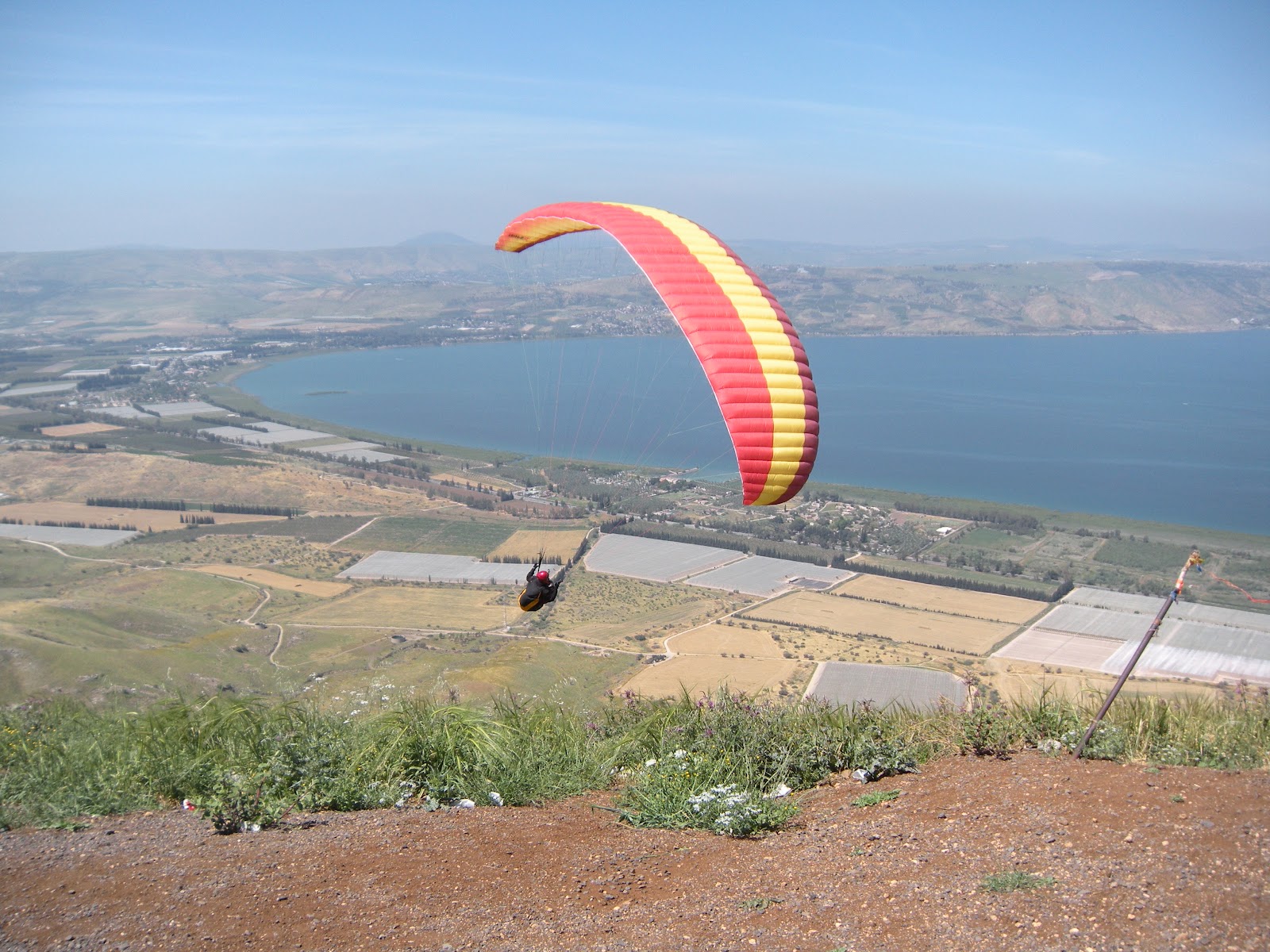
As we neared the cliff face separating the Golan plateau from the Jordan River Valley, we noticed a gathering of people around a bunch of hang gliders, and we sat back and watched people take flight down towards the Galilee.
 |
| Look ma, no hands |
We finished the rest of the hike in ease, and caught a ride to Kibbutz Degania where we stayed with Ari's friend Franco. Friday afternoon and Saturday were spent relaxing, unwinding, ropeswinging into the Jordan River, and hanging at the beach on the Galilee
So I guess that's pretty much it...The Golan Trail. It was fun.
The Wave - Miike Snow